Mt. Baker standing at the height of 10,781 ft is an active stratovolcano (similar to Mt. Rainier). A stratovolcano, or composite volcano, is a conical volcano built up by many layers of hardened lava. It has a steep profile with a summit crater and is characterized by regular eruptions (thus forming layers). The glacier cover of Mt. Baker is exceeded only by Mt. Rainier among Cascade Range volcanoes. The name Mt. Baker was given by Geroge Vancouver in honor of his friend Joseph Baker in 1792. It was during the same expedition that his team had discovered Mt. Rainier as well, which he named after Rear Admiral Peter Rainier.
Mt. Baker is nestled in its eponymous Mt. Baker Snoqualmie National Forest which is located on west side of the Cascades between Canadian border and Mt. Rainier National Park.
What is the difference between National Forest and National Park?
As I was reading about Mt. Baker, I learnt an interesting fact that Mt. Baker wilderness is a national forest, not a national park. The difference between National Forest and National Park is not the type of land, geography, or wildlife, but rather the management. Both national forests and parks are federally managed land. National forests are managed by the United States Forest Service (USFS) which is part of United States Department of Agriculture (USDA) while national parks are maintained by the National Park Service (NPS) which is part of the US Department of Interior. The difference between national forests and national parks lies in their vision statement. National parks emphasize strict preservation of pristine areas “unimpaired for future generations”. National forests, on the other hand, emphasize the concept of “multiple use”. They provide Americans with a wide variety of services and commodities including lumber, cattle grazing, mineral products, and recreational activities. As an example, national parks usually forbid hunting while forests allow it. Dogs can be taken to national forest trails, but not in the national parks. There are 155 national forests while 63 national parks in the US. Shoshone National Forest was the first national forest set up in 1891, 19 years after the establishment of the first national park, Yellowstone in 1872. Notice the difference in domain name of Mt. Baker-Snoqualmie National Forest and Mount Rainier National Park – one is usda.gov, while other is nps.gov – signifying who manages what. You can read more about this here – National Park Or National Forest?
This difference in national park vs. national forest usage reminded me of a recent movie I watched – Kantara. In the movie, forest officials wanted to designate an area as a forest reserve while villagers were against it as it would have stripped them of their privilege of using forest’s resources and hunting.
Fall colors hike in Mt. Baker wilderness – October 15th , 2022
As the summer recedes, so does the crowd from hiking trails. Weather starts to become unpredictable. People take shelter against the grey clouds and colder winds. That trumpets the arrival of winter helmed by autumn, what people in the US like to call “fall”. Washington may not have the sweeping views of deciduous trees as that of east coast, but what we have is still quite beautiful. Roads are dotted with golden larches, orange maples and yellow alders under bright crisp blue skies. Forests are carpeted with a colorful bed of shrubs on which green coniferous trees stand tall. Instead of cocooning oneself, I believe it is a good time to go out and witness the colorful wheel of hues that mother nature is spinning.
So, in the same spirit, we thought of going on a hike in Mt. Baker Snoqualmie National Forest to see the fall colors. There were 3 of us – Raj, Gopi, and me. The trail we agreed upon was this – Explore Iceberg Lake via Chain Lakes Trail | AllTrails. It was an easy 4 miles round trip hike which usually takes 2 hours to complete.

I went to Raj’s house the day before and slept there itself. Gopi lived nearby so he joined us in the morning the next day. We started at dot 5 AM in the morning. It was a long 2.5 hours’ drive, but we did very good on time. By 7.30, we reached Pictures Lake. Due to forest fire in nearby Okanogan-Wenatchee National Forest the sky was covered with smog. But as the sun came up smog cleared, and weather gradually became better. We started the day with a short walk around the picturesque Picture Lake which cradles the perfect reflection of Mt. Shuksan in its clear, still water.


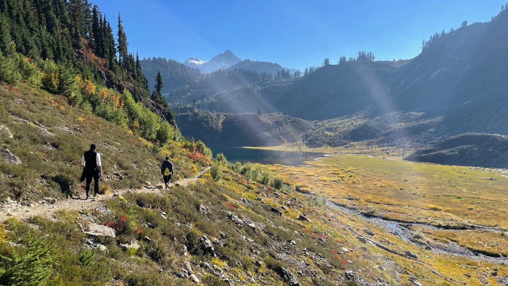
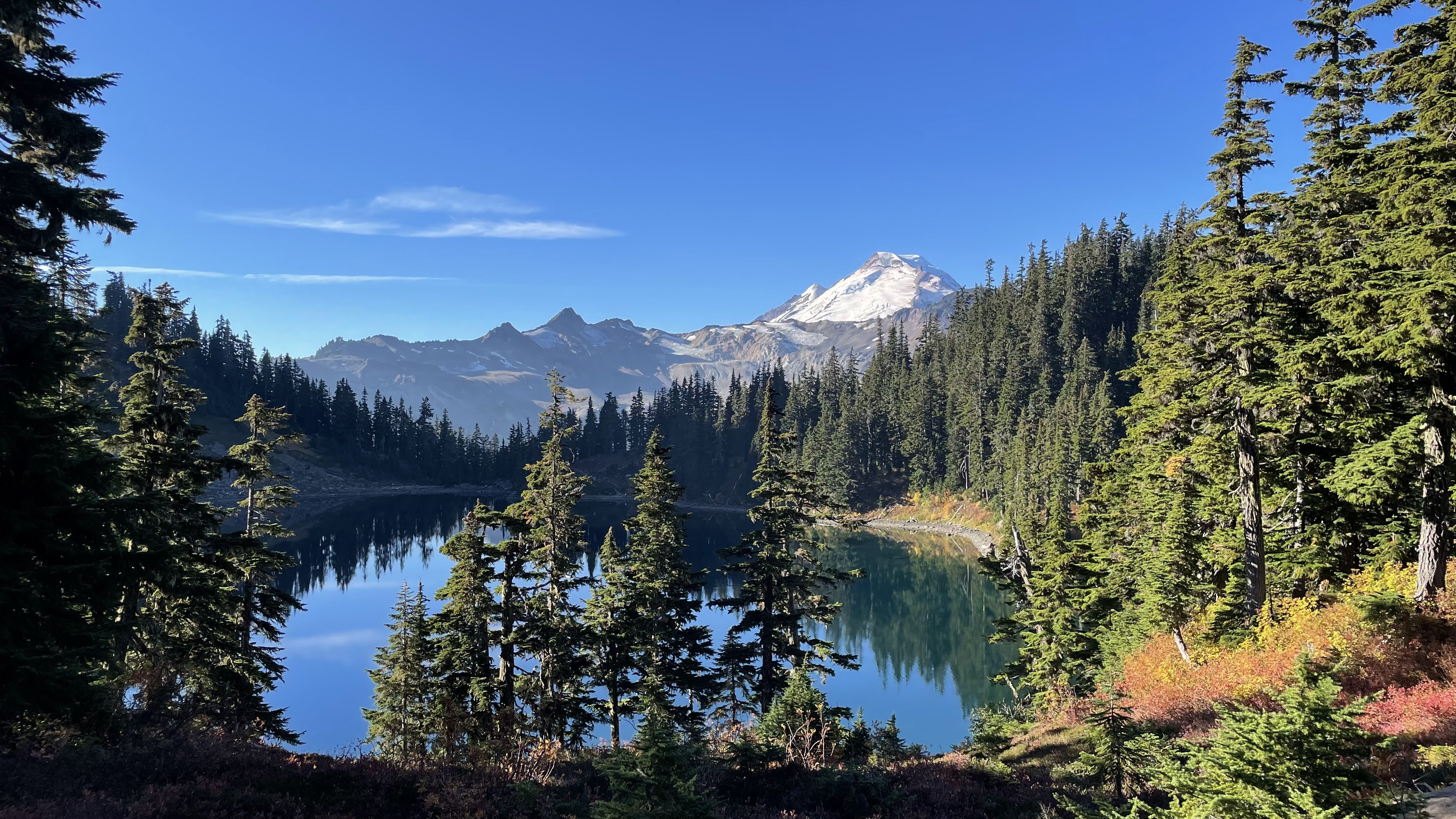
After this, we drove to the Artist Point which was the trailhead of our Chain Lakes trail. At 8 AM, we had set foot on the trail. The initial stretch was dusty with loose rocks and gravel. But we didn’t have to wait long before the colors started showing up. Ptarmigan Ridge trail and Chain Lakes trail overlaps for the first ½ hours or so before Chain Lakes trail forks towards right and Ptarmigan trail continues straight and descends into a valley. We took the right turn. And we were rewarded soon after. Mt. Baker revealed itself in front of us. We clicked a few photos and continued on the trail. By 9 AM, we reached the Iceberg Lake. Raj had packed some puliyogare (tamarind rice) for us. On our way, we had bought some Starbucks Frappuccino. So, it was good, sumptuous breakfast by the hiking standards 😊.


As we headed further towards Hayes Lake the sun had started shining and the bright colors showed. Till now, the vista was a bit dull but all of it changed the moment we reached Hayes Lake, which is on the other side of Iceberg Lake. Purple, red and orange shrubs were blooming adjacent to the turquoise water of the Iceberg lake. Tall pine-filled mountains were looming large from all directions. And snow-capped Mt. Baker glistened in the bright sun.


Hayes Lake is where we were supposed to return. It was 10 AM by now. It would have been another 1 hour of hike back to the Artist Point where we parked the car. But we discussed and agreed to do the loop, instead of going out-and-back. We were a bit uncertain of the length and route but asked a couple of fellow hikers. They nudged to do the loop. A lady said if we do the loop, it is mostly downhill with beautiful views (which turned out to be not entirely correct 😉). It inspired us and we went ahead with doing the full loop of Chain Lake trail.
Chain Lakes Loop Trail | Map, Guide – Washington | AllTrails
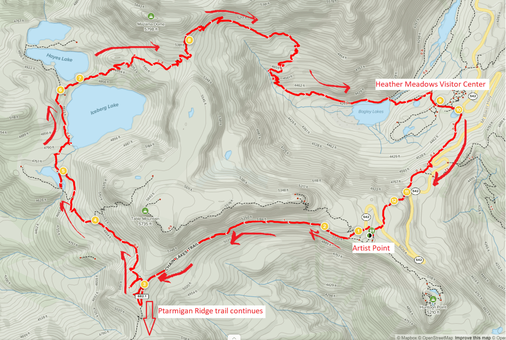
The views were amazing. As we walked around Iceberg Lake and further, Mt. Baker stayed with us all along. But it was strenuous. There was about 600 feet of elevation gain before the downhill started. The loop takes you to Bagley Lake near Heather Meadows Visitor Center. We were very tired by now. The planned 4-miles hike had become 7-miles. But it was not over yet. We had to now hike up about 700 feet for another mile from there to the Artist Point where our car was parked. When we were walking up from Heather Meadows Visitor Center towards Artist Point, Raj dropped his wallet somewhere in between. He decided to trace back his path and asked us to keep going, get the car and pick him up from the Heather Meadows itself. The final stretch was extremely strenuous and took much longer than expected. Sun was at its peak constantly sapping energy and water out of our body, both of which we were running out of. Finally, we reached Artist Point by 12.30 PM. It took us more than 30 min to hike up the last 1-mile stretch. We drove to Heather Meadows to pick Raj up. Thankfully he had found his wallet, and all was well. After that it was a sleepy 2.5 hours’ drive back home.
Overall, it was a rewarding unplanned adventure but there were a few learnings. In the hindsight, I realized that Chain Lakes trail is better done counterclockwise. Start at Heather Meadows Visitor Center and go counterclockwise reaching Artist Point at the end. That way you will be descending from Artist Point, instead of ascending up as we did. This trail had minimal to none shade, so ensure that you have sun protection and extra water bottles. Learn from the mistakes we did 😊.